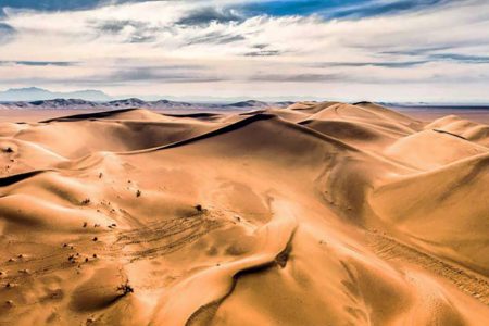
Deserts of Iran
Iran is a land of striking contrasts in the Middle East. Lush forests, mountain ranges, waterfalls, seas, lakes, and vast deserts together shape the geography of this beautiful country. Almost one-third of Iran is covered by desert regions, mainly located in the provinces of Isfahan, Yazd, Kerman, South Khorasan, and Semnan.
The desert areas of Iran encompass two major deserts: Dasht-e Kavir and Dasht-e Lut, each of which comprises several smaller deserts and unique landscapes. Dasht-e Kavir (also known as the Great Salt Desert or Kavir Markazi) is the largest desert in Iran, spanning the central plateau. Dasht-e Lut, or the Lut Desert, stretches between the provinces of South Khorasan, Kerman, and Sistan o Baluchestan, and is one of the hottest places on Earth.
With their starry skies, golden dunes, breathtaking silence, and endless horizons, Iran’s deserts offer unique experiences to adventurous travelers. The best time to visit them is in early spring, autumn, or winter—preferably from sunrise to sunset, when the desert reveals its full beauty.
Dasht-e Kavir (Great Salt Desert)
Located in the central plateau of Iran, Dasht-e Kavir is the country’s largest salt desert, covering about 77,600 km² at an altitude of 700 meters above sea level. It stretches from the Alborz mountain range down toward central provinces such as Qom, Isfahan, Semnan, and South Khorasan.
Within Dasht-e Kavir lie many famous deserts, including Band-e Rig, Maranjab, Abu Zidaabad, Varzaneh, Khor and Biyabanak, Jandaq, Mesr, Garmeh, Chupanan, Rig-e Jenn, Siah Kuh, and Matin Abad. Two significant protected areas, Kavir National Park and Kharturan National Park, are also located here. The Salt Lake near Qom marks the western edge of this desert.
Dasht-e Kavir is characterized by very cold winters, extremely hot summers, scarce rainfall, and salty marshlands. Vegetation is limited to hardy, salt-tolerant plants like halophytes, though scattered shrubs and grasses appear in some areas. Wildlife includes rare species such as the Asiatic leopard, sand cat, and sand fox, alongside various birds, reptiles, and amphibians.
The desert is also home to Iran’s largest dune, Rig Boland, located between Aran va Bidgol and Ardestan in Isfahan province. Among its well-known dunes are Ashiyane-e Oghab and Tel-e Sheytan-e Zavareh.
Dasht-e Lut (Lut Desert)
Dasht-e Lut, located in southeastern Iran, covers about 51,800 km² across the provinces of South Khorasan, Kerman, and Sistan o Baluchestan. Known by different names—Chale Lut, Kavir-e Lut, or Biyaban-e Lut—it ranks as the world’s 25th largest desert and is famous as one of the hottest places on Earth. From 2004 to 2009, satellite measurements recorded Lut as the hottest point on the planet.
The Lut Desert is dominated by sandy plains and unique geological formations. Its most famous attractions are the Kaluts of Shahdad in Kerman, extraordinary yardangs shaped by centuries of erosion, which UNESCO has recognized as a World Natural Heritage Site. The desert also contains the world’s tallest and longest ridges and cliffs, making it an extraordinary natural wonder.
Band-e Rig Desert
Band-e Rig is a vast horseshoe-shaped desert strip within Dasht-e Kavir. It consists of three main areas: Rig-e Boland, Posht Rig, and Maranjab. Located between Isfahan’s Namak Lake in the south and Abu Zidaabad in the north, Band-e Rig connects to the Maranjab Desert and Kavir National Park.
Maranjab Desert
Situated in Isfahan province, north of Aran and Bidgol, the Maranjab Desert is one of the most scenic areas of Iran’s central desert. It is bordered by Masileh Desert and Hoz-e Sultan Salt Lake to the west, Band-e Rig and Kavir National Park to the east, Namak Lake to the north, and Aran & Bidgol cities to the south. The main access route is through Ab Shirin village on the Tehran road.
Vegetation consists mainly of salt-resistant plants such as gaz trees, haloxylon, and shrubs, while diverse wildlife thrives here, including cheetahs, jackals, wolves, sand cats, foxes, and birds of prey.
Highlights of Maranjab include rolling dunes, white salt lakes, the historic Maranjab Caravanserai (Safavid era), Tagh Forest, and Jazireh-ye Sargardan.
Abu Zidaabad Desert
Located northeast of Kashan, near Abu Zidaabad village, this desert belongs to the Band-e Rig area of Dasht-e Kavir. With underground water tables, vegetation is more visible here than in other deserts. Wildlife includes sand foxes, jackals, wolves, falcons, and rabbits.
Visitors can enjoy off-roading, motorbiking, camel riding, and stargazing. The desert also features Siazga (Rig Siyah) dunes and the historic Karshahi Castle, Iran’s second-largest adobe monument after Bam Citadel.
Varzaneh Desert
Located east of Isfahan and stretching over 170 km², the Varzaneh Desert lies 117 km from Isfahan and 150 km from Yazd. It is close to the Gavkhouni Wetland, making it an ecologically unique area.
As the largest desert recreational hub in Iran, Varzaneh offers activities such as camel riding, sandboarding, off-roading, buggy riding, and zip-lining. Its sunrises, sunsets, and starry nights are particularly famous.
Jandaq Desert & Mesr Desert
Jandaq Desert, located near Khor city in Isfahan province, has a history of over a thousand years. Close by lies the Mesr Desert, one of the most popular tourist spots. Mesr village features reed fields, underground water wells, camel riding, desert homestays, and stargazing opportunities.
Garmeh Desert
Garmeh, a thousand-year-old village in Dasht-e Kavir near Khor, is known for its mineral springs, date palm groves, flowing dunes, and Sassanid-era ruins. Its people speak a dialect of Pahlavi, and the village is rich in agriculture, producing dates, pistachios, almonds, grapes, and apricots.
Chupanan Desert
Located east of Anarak in Isfahan province, the Chupanan Desert surrounds a historic village established around an ancient aqueduct. The area is rich in history, with nearby Nakhlak Mine (2000 years old), fortresses, and Sassanid shrines.
Rig-e Jenn Desert
Rig-e Jenn, a 3,800 km² desert, lies in southern Dasht-e Kavir and borders Kavir National Park. Known for its mysterious legends and difficult terrain of salt swamps and dunes, it was long considered impassable. Natural phenomena such as the “crying rocks,” caused by temperature changes, cracking stone surfaces, add to its eerie reputation.
Kavir-e Siah Kuh
Also called the Aqda Desert, this moon-shaped desert lies near Ardakan in Yazd province. With salt marshes, swamps, and extreme temperature variations, it has limited vegetation and fauna. Strong winds and barren landscapes define the area.
Matin Abad Desert
Near Natanz in Isfahan province, Matin Abad Desert lies on the edge of Dasht-e Kavir. Its climate ranges from -12°C in winter to +46°C in summer. Despite this, vegetation is richer than in many other deserts, with plants like gaz, haloxylon, and milkvetch. Wildlife includes hares, birds, and even the rare Asiatic cheetah.
Matin Abad is popular for eco-tourism activities such as stargazing, camel riding, off-roading, photography, and visits to Namak Lake.
Kalut Shahdad Desert
Located northeast of Kerman, Shahdad Desert lies on the western edge of Dasht-e Lut. It’s famous Kaluts (yardangs) cover an area of 11,000 km² and are among the world’s most spectacular desert formations.
Archaeological findings suggest that Shahdad was inhabited as early as the 3rd millennium BC. Ancient cemeteries, water reservoirs, caravanserais, and castles remain scattered across the desert. The area is also home to the world’s oldest metal flag, Derafsh-e Shahdad.
Kaluts are divided into three zones: green (open access), orange, and red (permit required with guides). The desert is also known for phenomena like salt polygons near Namak Lake and the mysterious “Silent Life” zone, where no living organism survives.
Final Notes
Deserts of Iran are more than barren wastelands—they are living landscapes filled with history, biodiversity, and natural wonders. From the blazing Lut Desert to the cultural richness of Maranjab and Mesr, each destination offers travelers unforgettable experiences of silence, stars, and adventure.
For further exploration of Iran’s deserts, particularly the UNESCO-listed Lut Desert, you can refer to several reliable sources. The NASA Earth Observatory provides striking satellite imagery and insights into its extreme climate, while Encyclopædia Britannica offers a detailed geographical overview. For official documentation of its World Heritage status and outstanding natural features, visit the UNESCO World Heritage Centre.